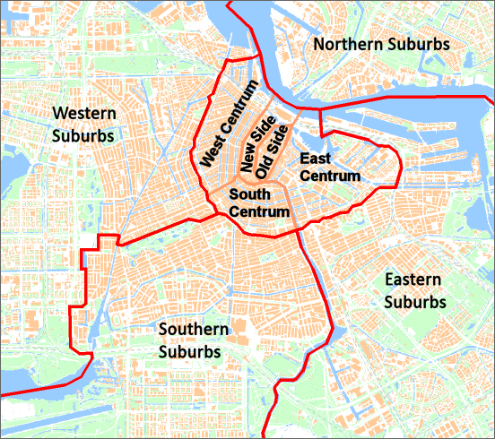
The majority of coffeeshops are in the centre of the city with progressively fewer in each concentric ring moving outwards from the centre. For this reason the ACD has five index pages covering the compact Centrum district and only four covering the remaining outer suburban districts.
Starting in the middle, the heart of the city is represented by the Binnenstad (1012 postcode). This, in turn, is divided into
Old Side
and
New Side, being the right and left banks of the former Amstel River, now marked by the Damrak and Rokin. Centraal railway station is at the northern end of the Binnenstad and Dam Square is in the middle. The main Red Light District is on the
Old Side.
Outside of the Binnenstad, the remainder of the Centrum district is dominated by the Grachtengordel (canal belt). This semi-circular band is made up of three segments, named here as
West Centrum,
South Centrum
and
East Centrum. The popular tourist squares of Leidseplein and Rembrandtsplein are in
South Centrum.
The outer limit of Centrum is marked by the Singelgracht canal and the IJ. Beyond Centrum are the
Western Suburbs,
Southern Suburbs,
Eastern Suburbs
and
Northern Suburbs.
Within these pages, streets are grouped by borough, district and neighbourhood. The boroughs are the modern administrative entities and districts are the areas cited on street nameplates. Neighbourhoods are more informal areas within districts. In a few cases neighbourhoods are further subdivided into smaller communities. Only those neighbourhoods that contain (or have contained in the past) some coffeeshops, headshops, growshops and smartshops are listed here.
|
Borough: Amsterdam-West
Borough: Amsterdam-Westpoort
Borough: Amsterdam-Nieuw-West
|
Borough: Amsterdam-Oost
Borough: Amsterdam-Zuidoost
|
|||
|
Centrum
Borough: Amsterdam-Centrum
|
||||